EXDIMUM was a joint project for the research and development of digital methods and tools for extreme water management. It was funded during the official project period from 01.02.2022 to 31.07.2025 within the funding line WaX - Wasser-Extremereignisse by the Federal Ministry of Research, Technology and Space (BMFTR, formerly Federal Ministry of Education and Research - BMBF).
The main objective of the EXDIMUM project was to address extreme water management within the spectrum of complex challenges. This is based on the observation that global climate changes not only affect average precipitation values but also amplify extremes such as severe droughts and local heavy rainfall events. These developments create challenges that occur simultaneously on different scales: low vs. high water volumes, regional vs. local areas, long vs. short time spans, mountain slopes vs. flatlands, and different land uses including forests, mining, agriculture, and urban areas.
The research approach was based on a holistic combination of data collection and modeling across multiple scales and derived measures. This particularly included the use of temporally and spatially high-resolution satellite imagery, the incorporation of digital terrain models, and the targeted, reliable collection of terrestrial sensor data. The integration of these multimodal data sources for condition assessment and scenario analysis served as a basis for short- and long-term forecasts and enabled well-founded recommendations for dealing with extreme weather events.
An extesive presentation of the project and its results can be found in an overview article in the specialist journal Hydrologie und Wasserwirtschaft (HyWa).
The core objective of the work planned in the EXDIMUM project was to address extreme water management within the spectrum of complex challenges (low vs. high water volumes, regional vs. local areas, long vs. short time spans, mountain slopes vs. flatlands, different land uses including forests, mining, agriculture, and urban areas) through the holistic interplay of data collection and modeling across multiple scales and derived measures. This particularly included the use of temporally and spatially high-resolution satellite imagery, the incorporation of digital terrain models, and the targeted, reliable collection of terrestrial sensor data. The interplay of these multimodal data sources for condition assessment and scenario analysis was intended to serve as a basis for short- and long-term forecasts and to allow the derivation of promising recommendations for dealing with extreme weather events.
This approach is based on the observation that global climate changes not only bring changes in average precipitation values but also amplify extremes of severe droughts and local heavy rainfall events. This development creates challenges that occur simultaneously at different scales.
Due to this complexity and interweaving of extremes from ongoing climate development, the effects of climate change cannot be understood and managed either through simple time series analyses or by reduction to individual aspects. Therefore, with EXDIMUM we pursue a holistic approach to considering the scales mentioned above and the interplay of individual aspects, in order to enable long-term planning and short-term forecasting, and to provide in real time a broad spectrum of appropriate responses to extreme weather events. As a result, this will also make it possible to observe and influence risks for municipalities (flooding), watercourses (spread of sediments dissolved from soil), and forest stands (vitality and pest infestation). In doing so, we go beyond previously used data analysis methods (with or without artificial intelligence methods) to enable prediction and management of currently observed developments through the linking of different spatial and temporal scales. This makes it possible to develop a deeper understanding of the characteristics of locally occurring events due to global changes, in order to then take meaningful regional measures at the catchment basin level.
Climate change becomes particularly evident in the Harz, the highest upland region in northern Germany. Whereas the average annual precipitation in Braunlage in the Harz was still 1376 mm in the years 1990–2009, it averaged only 983 mm between 2010–2019. Such long-term decline in water availability affects the entire country; its effects appear earlier and more clearly in a natural landscape like the Harz than in agriculturally and culturally managed areas, where temporary massive interventions (e.g., intensive groundwater irrigation) make the problem recognizable only later and thus ultimately even more serious. Additionally, natural landscapes are less intensively studied due to lower short-term economic interest, although the effectiveness of measures would be easier to control. Better understanding is particularly important for early, more accurate analysis of the altered water balance of adjacent, semi-natural cultural landscapes – especially since, in the course of overall development, extremes in both directions have increased, with sometimes significant and highly localized precipitation. Despite the ability to dampen floods using the dams in the Harz with reservoir volumes of 360 million m³ and thus protect the surrounding area from resulting flood waves, the Harz has experienced twice in recent years (2014 and 2017) situations where, after heavy rainfall, surrounding municipalities were exposed to uncontrollable flood waves. The capacity of existing retention areas was far exceeded. Such situations pose enormous challenges not only for the operators of municipal drainage infrastructure, but also for water associations, fire departments, and technical relief organizations.
Due to the complexity and intensity of challenges in the Harz (which was intensively studied as the pilot region in the EXDIMUM project), it became clear that the comprehensive methods and models developed were designed to enable significant progress for numerous other regions and landscapes, particularly through the linking of different data sources and expertise. The special approach of considering multiple scales in a domain jointly and in context, and developing methods for their interlinking, proved forward-looking and both methodologically relevant and practically useful. This methodological contribution delivered innovations; in particular, it became evident during the course of work which scales and data are relevant for the application area and must be included in forecasts and simulations. The project was structured so that the various methodological contributions were linked in the overall model; however, this was done in a modular way so that flexible combinations were possible and there was no excessive dependency on individual partial results, which also enabled transferability to other scenarios. The methods, techniques, and solution patterns developed could be directly implemented through extensive involvement of practice partners, who in turn had broad impact through their professional networks. Thus, through both the structure of the overall project and the choice of cooperation partners and methods applied, the success prospects of EXDIMUM were maximized.
As climate change progresses, extreme weather events such as droughts and heavy rainfall occur more frequently and present complex challenges for municipal water management. The effects of this development are particularly evident in Goslar and its catchment area in the Harz: steep slopes, large retention areas, and historically grown infrastructures often no longer suffice to handle dynamic runoff processes and the risks of rapidly emerging flood events. At the same time, years of tree die-off due to droughts and pests lead to noticeable changes in land cover—with far-reaching consequences for soil erosion and water balance.
To systematically incorporate practical needs and challenges into the project, a comprehensive survey was conducted at the start among regional network operators, municipalities, fire departments, and other relevant stakeholders. The survey results underlined the urgency of new solutions: almost all respondents reported having already been affected by flood events caused by heavy rainfall—yet only a small minority had regular training experience in handling such situations. There was a particularly strong desire for support in improving data foundations and measurement density, technical flood protection measures, effective communication and collaboration, and the use of modern modeling and forecasting tools. Fewer than a quarter of respondents felt their needs were sufficiently met; instead, additional, easily accessible solutions for analyzing, forecasting, and visualizing extreme water events were demanded.

These requirements fundamentally shaped EXDIMUM's scientific approach: from the outset, expertise from hydrology, algorithms, remote sensing, and practice was systematically combined to develop tailored digital tools and methods that deliver tangible benefits in real-world use.
The interdisciplinary approach of EXDIMUM closely linked methods from algorithms, hydrology, remote sensing, and water management with practical requirements. The focus was on targeted enhancement and integration of diverse data sources within a project-specific analysis and visualization platform.
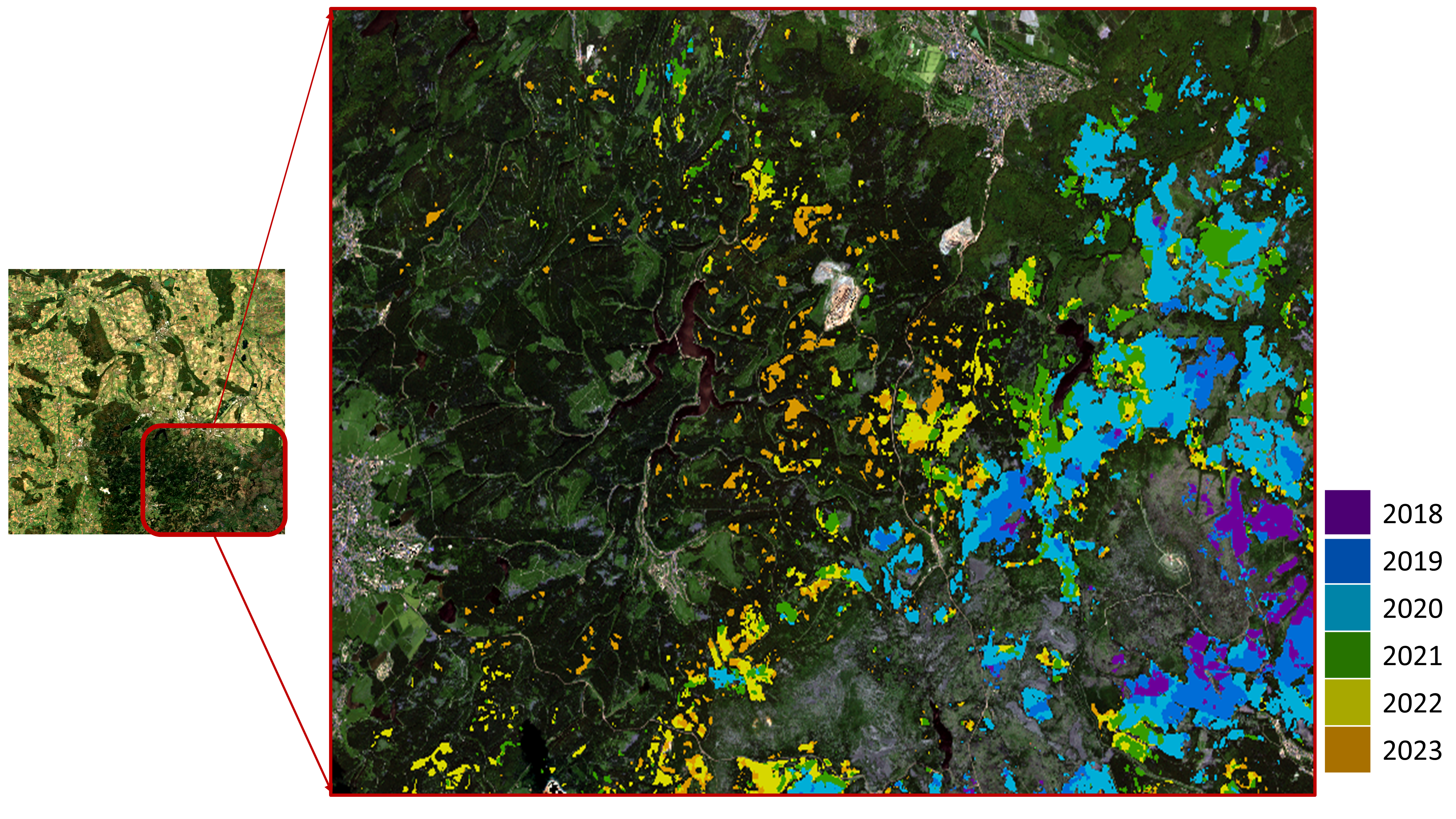
Central to this is the use of AI-based deep learning algorithms for analyzing Sentinel-1, Sentinel-2, and PlanetScope data. Annual high-resolution land-use and vegetation maps were generated, enabling automated distinction between coniferous forest, deciduous forest, dead trees, and emerging grassland for the first time. Using the AI technique of self-supervised learning allowed robust, high-resolution soil moisture estimates in space and time, even in data-sparse regions.
A digital terrain model with 1 m grid spacing forms the basis for detailed simulation of runoff paths, flooding dynamics, and retention behavior. These data are combined with current building and road data from official sources and OpenStreetMap, as well as remote-sensing-based information on soil type and land use.
Custom sensor networks developed for EXDIMUM with ultra-low-power hardware provided measurements every ten minutes for water levels, rainfall, soil moisture, temperature, and air pressure. Specialized AI-based sensors for monitoring drainage grates closed a previous gap in monitoring flowing waters. Wireless transmission was handled via an adapted LoRaWAN infrastructure; technical extensions such as the ELORA protocol and on-board prediction models for signal quality significantly increased reliability even during heavy rainfall and other extreme conditions.
All data types were linked within a modular, web-based platform. It enabled processing and near-instant visualization of information on polygon-based, interactive maps. The platform used a fine-grained layer structure and GeoJSON-based segmentation so that different user groups—from emergency responders to planners—could access relevant data in a targeted, role-based manner. Newly generated and external data could be flexibly integrated to keep modeling and forecasts continuously up to date.
A central aspect of EXDIMUM is the methodological advancement and efficient implementation of numerical methods to represent heavy rainfall events in heterogeneous catchment areas.
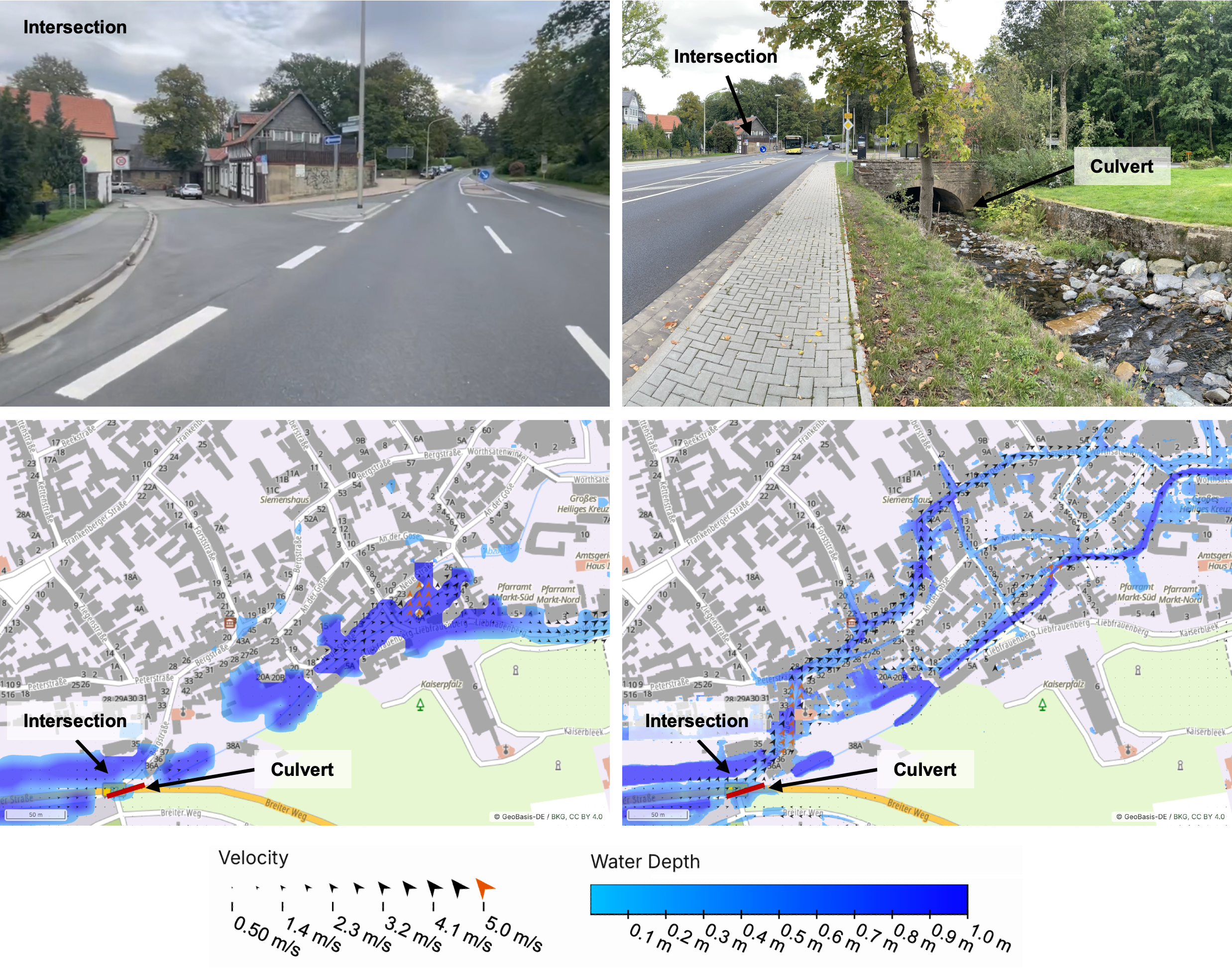
Hydrodynamic surface-runoff simulations are based on high-resolution digital terrain models. To ensure the necessary model precision with acceptable computational effort even for extensive study areas, an adaptive mesh-refinement method using a quadtree data structure was implemented. Fine grids are applied in critical subareas—such as around buildings, roads, or key culverts—while less critical areas are modeled at coarser resolution. This approach achieves a substantial reduction in simulation runtimes with comparable result quality. Initial applications in complex regions show that the resulting simulations provide robust and plausible insights into flow paths and inundation areas.
As a complementary method, a depression-free flow graph was introduced. It describes the hydrological structure of catchment areas independent of small-scale terrain depressions, enabling automated identification of flow paths and critical reaches. These key segments can be assigned high model resolution, optimizing resource allocation and increasing relevance for critical processes.
To further increase efficiency, the study area can be segmented into core and boundary regions. The core area—often urban or highly flood-prone zones—is modeled in high detail, while adjacent boundary areas use coarser resolution. Appropriate boundary conditions for inflow and outflow between these segments ensure physical consistency of the simulation.
To support large simulation series, a script was implemented that automates the creation of simulation configurations for the TUFLOW modeling system. Based on a structured input file, investigation parameters, terrain data, adaptive resolution, and additional model options can be specified variably and efficiently. This facilitates extensive scenario analyses and transferability to other study areas.
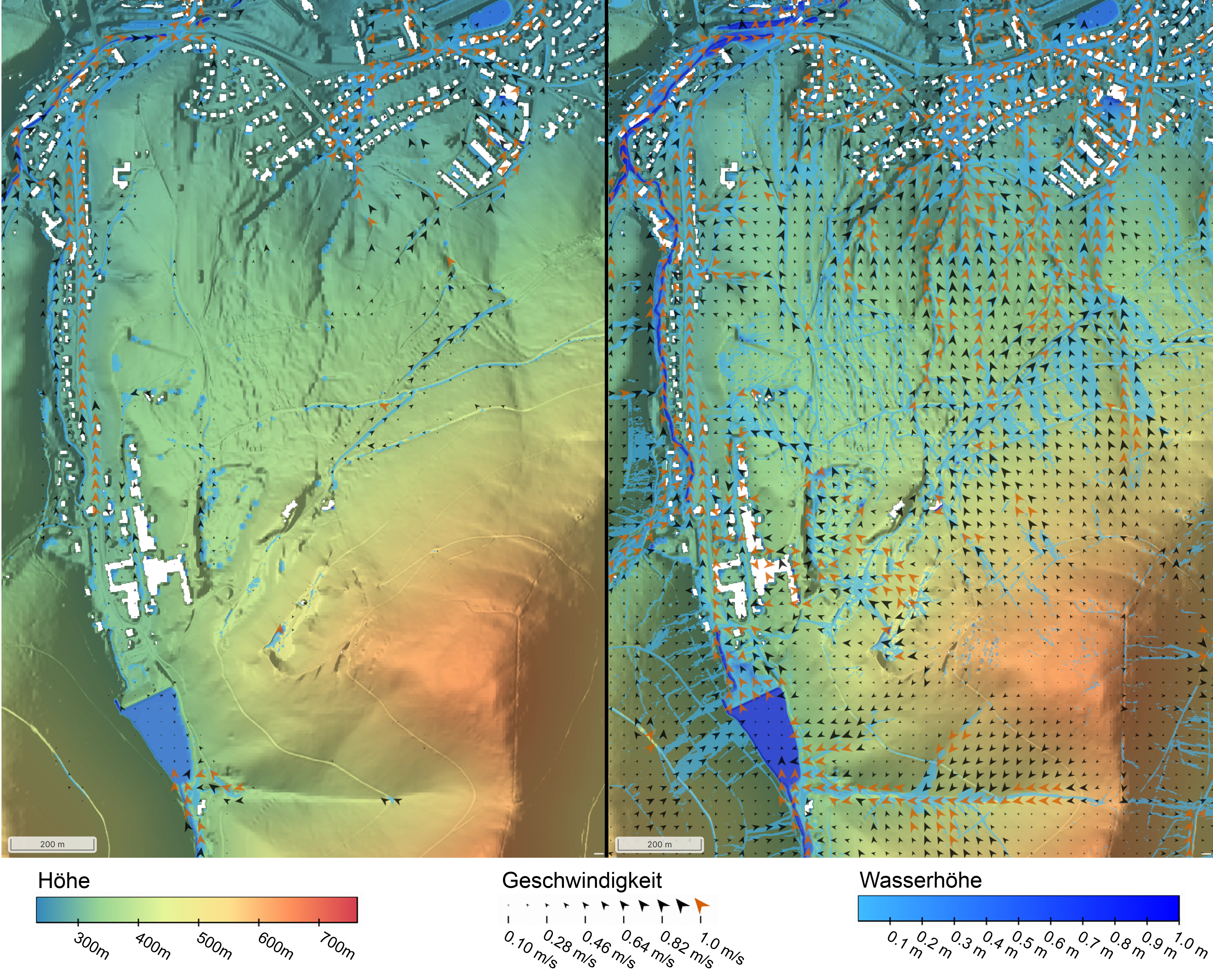
The methods were applied to various heavy rainfall and flooding scenarios for the city of Goslar. Simulation-based statements on flow paths, water levels, and inundation areas have so far undergone plausibility checks using anecdotal historic flood events and photo/experience reports; systematic validation with independent measurements is still pending. Procedures were also developed for automated detection of critical warning levels based on simulation results for water levels, flow velocities, and volumes. Comparing simulation results with slightly different input parameters allows conclusions about particularly critical constellations where small local changes—such as structural protection measures—could have significant impact. Overall, the implemented methods enable efficient, flexible, and practitioner-adaptable analysis and evaluation of hydrodynamic risks in extreme situations.
The transferability of the approaches was demonstrated during the project. The overall technical system, including sensors, the central data platform, and simulation algorithms, was applied not only in the Harz region but also in additional pilot and transfer regions with similar challenges. Land-use and soil-moisture data were used in external research projects and integrated by partners from agriculture and forestry into their work. Follow-on activities continue selectively with individual partners.
Despite the current prototype character of many components, there is already broad interest from various stakeholders in the developed solutions: authorities and infrastructure operators are exploring integration of the sensors into existing systems and assessing benefits for their own hazard response and planning. Notably, the capabilities for flood forecasting, warning-level determination, and scenario analyses can support fire departments and disaster management authorities in both acute incident management and the design and evaluation of protection measures, emergency drills, and response plans. The agriculture and forestry sectors have expressed interest in sensor packages—especially for moisture monitoring—as well as continued use of land-cover and soil-moisture data. Engineering and consulting firms are exploring ways to embed the developed software modules into existing workflows. Discussions with practitioners, especially roundtables with local stakeholders, have yielded positive feedback on the modeling and data management platform. Scientific publications demonstrate the relevance and applicability of the approaches beyond EXDIMUM.
Strong interest in both individual components and the overall system clearly shows the broad exploitation prospects of the techniques and their transferability beyond the demonstrated applications and transfer regions. Overall, EXDIMUM demonstrates how well-aligned digital tools based on current science and close user involvement can deliver not only innovation impulses to research but also tangible improvements and an important foundation for future advancements in practical extreme water management.
This work package initially identified relevant use cases and the data required for them. Additionally, the system architecture of the overall system was conceptualized.
In this work package, a data collection system for terrestrial data was developed that operates reliably even under extreme weather conditions and was deployed at relevant locations in the pilot region.
The main task of this work package was to develop data processing mechanisms for the analysis of satellite images using artificial intelligence (AI). This included the detection of vegetation, vegetation status, soil moisture, land use, and other parameters identified in WP1.
The primary goal of this work package was to make Digital Terrain Model data (DTM data) usable within a multiscale model and, through simplification of complex geometries, enable rapid and accurate representation and interpretation.
This work package covered not only the technical integration of data sources but also the development of scalable and efficient internal data representations to enable targeted, low-latency access to all available information.
The aim of this work package was to derive innovative, data-driven mechanisms, for instance using signal processing and data fusion techniques from the field of AI. In combination with established knowledge, it aimed to gain a deep understanding of the impact of extreme water events on a given region and to derive recommendations for action and prevention.
In this work package, suitable user interfaces were designed and implemented to allow professional users to operate the overall system without requiring specialized prior knowledge.
Continuous comparison of research and development aspects with practical requirements ensured the goal orientation of the project. Primarily, the potential of the multiscale approach was examined in the pilot region around Goslar, where partner EW already possessed comprehensive knowledge of local conditions.
In addition to organizing regular consortium meetings, this work package coordinated the presentation of project results both within and outside the consortium.
In addition to consortium leadership, the Technical University of Braunschweig (TUBS) made two essential scientific contributions to the project. The scientific objectives of remote sensing at TU Braunschweig (TUBS-IGP) included the development and provision of methods for remote sensing and machine learning to derive topographic information and soil moisture parameters from passive and active satellite-based sensor data. An important goal was to link these methods with specific knowledge from application partners in water management and individual measurements through terrestrial sensing. This was connected to the further objective of making an important contribution to data preparation and modeling for the multiscale model to be developed, and then participating through predictive models in the derivation of possible actions. The emphasis of the scientific-technical objectives of algorithms at TU Braunschweig (TUBS-ALG) lay in the development of algorithmic methods for water spreading and accumulation based on high-resolution terrain data. Geometric methods for analyzing occurring flow intensities, flow velocities, and terrain stress were investigated alongside large-scale and high-resolution target configurations. These aimed (in collaboration with UKI's hydrological expertise) at more accurate modeling and thus analysis and prediction of interactions between water and terrain, allowing more precise statements about temporal progression and erosion risks. This resulted in interactions with the use of ground-based sensor data (which allowed better capture of actual conditions and progression) and also provided insights for the overall model described below and subsequent recommendations for action.
The role of the Christian Albrechts University Kiel (UKI) in the overall project aimed at improved spatially distributed modeling of water and sediment balance during extreme events. This included improved consideration of extreme events in model calibration, model-based spatially distributed analysis of impacts of hydrological extreme situations, model-based derivation and evaluation of land-use management strategies, and model-based investigation of impacts of hydrological extremes on sediment discharge.
In the subproject of Clausthal University of Technology (TUC), the goal was to reliably, regardless of weather conditions and promptly after collection, provide terrestrial data collected in a study area. This created a foundation for initial calibration, continuous improvement, and timely updating of multiscale models that could not be achieved with then-current state-of-the-art technology. The reason was that currently used wireless technologies either lacked sufficient network coverage outside densely populated areas (e.g., 5G/UMTS/LTE) and/or lacked mechanisms to reliably maintain latency limits (e.g., LoRaWAN, SigFox). The key objective was therefore to adapt LoRaWAN radio technology, commonly used for telemetry applications, to meet the requirements from project practice. The communication procedure was modified, extended, and/or recombined to maintain reliable connections even in extreme weather situations and to transmit terrestrially collected data at high resolution within permissible time limits.
These goals complemented those of the subproject of DSI Aerospace Technology GmbH (DSI-AS), which aimed at the prototype development of innovative sensor systems for capturing terrestrial soil and vegetation data. Due to the planned, relatively low-rate connection of individual sensor nodes via LoRaWAN transceiver modules, efficient preprocessing of raw data was implemented alongside system design, enabling high-precision extraction of all necessary parameters. The AI methods planned for this included, in particular, recognition and classification of specific states or objects performed on the sensor system itself, which drastically reduced communication overhead. Ultra-Low-Power (ULP) ICs were utilized for the realization of the sensor system, combining the characteristics of a highly integrated, powerful, flexible, yet cost-effective processing platform. To achieve the highest possible longevity of the sensor system, all components were examined for energy consumption, robustness, and expected costs. The resulting underlying hardware platform thus enabled the implementation of powerful sensor systems that optimally met special requirements (longevity, failure safety, reliable communication, etc.).
The goal of the subproject of REMONDIS Aqua Industrie GmbH & Co. KG (RAI) was to collect relevant data streams from the environment and water-bearing infrastructure in the sense of environmental monitoring and the Internet of Things. Using these data streams, the present could be mapped into a digital twin of the project region. On a modular basis, individual applications could be developed from the collected data that generated sustainable improvements in specific areas of the interplay between humans and nature as needed. Through the EXDIMUM project, partner RAI was given the opportunity to gain important insights regarding long-term use and reliability of terrestrial sensing and to clarify which sustainable use cases lead to real added value considering the "Triple Bottom Line" approach.
Individual aspects were integrated into a comprehensive digital model in the subproject of AMENO GmbH (AMENO), which aimed at creating an application for linking and displaying all relevant data for system users. For this purpose, a universal interface was developed and provided to centrally collect, validate, and make available all data from all data sources to all further subprojects. Behind the scenes, the application provided a coherent data basis for integrating the data evaluation procedures to be developed. This included various interfaces to data sources and sinks provided by other subprojects of the overall project, as well as - if necessary - data sources from third parties that positively influenced the quality of data analysis and presentation. In addition to the technical linking of data and systems, possible validation of incoming and outgoing information in the context of QoS (Quality of Service) played a role. The result was primarily a digital representation with which both sensor results and predictions of artificial intelligence as well as underlying raw data could be displayed. Various presentation methods were tested regarding usability - for example, a traffic light system for displaying sensor status or a map display of predicted water flows could be considered. The application was built modularly with clearly defined interfaces to create the foundation for later transferability and scalability and to enable integration of further data sources during project progression.
EURAWASSER Betriebsführungsgesellschaft mbH in Goslar (EW), as the operator of public drainage and flood protection systems in the Goslar catchment area, assumed the role of a liaison between research and science and practical application, and was involved as a consortium partner in all phases of the project. In this way, EW significantly helped to define the practical requirements essential for operators of existing systems and incorporated them into system development. With the help of the knowledge gained in the project, EW was able to adapt and optimize its existing action and operational processes in emergency situations where appropriate. The interaction with involved organizations such as fire departments, the city of Goslar, the Goslar district, and other stakeholders played an important role, where new impulses could be set through the communication and analysis platforms developed in the project. EW defined practice-oriented requirements for the development of the overall system and accompanied all project phases with regard to practicality, practical benefit, and suitability.
Prof. Dr. Sándor P. Fekete
Algorithms Division
Technische Universität Braunschweig
Mühlenpfordtstraße 23
38106 Braunschweig
Telefon: +49 (0)531 391 311 1
Telefax: +49 (0)531 391 310 9
E-Mail: s.fekete[[at]]tu-bs.de
Internet: Webseite Prof. Dr. Fekete bei der TU Braunschweig
Dr. Christian Rieck
Discrete Mathematics
Universität Kassel
Heinrich-Plett-Str. 40
34132 Kassel
Telefon: +49 561 804-4192
E-Mail: christian.rieck[[at]]mathematik.uni-kassel.de
Internet: Webseite Dr. Rieck bei der Universität Kassel
Tobias Wallner
Algorithms Division
Technische Universität Braunschweig
Mühlenpfordtstraße 23
38106 Braunschweig
Telefon: +49 (0)531 391 311 6
E-Mail: wallner[[at]]ibr.cs.tu-bs.de
Internet: Webseite Wallner bei der TU Braunschweig